FARO® Trek 3D Laser Scanning Integration

Enables autonomous scanning with the Boston Dynamics Spot® Mobile Robot
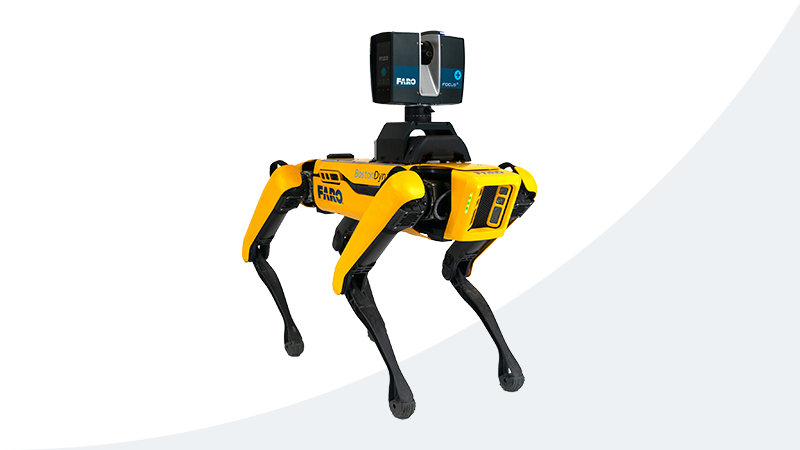
In the past, the only way to use laser scanners for reality capture on a construction site was to assign a worker to the task. But today, you can send in the Boston Dynamics Spot Mobile Robot instead. Just walk Spot through the project once to record your scanning mission, and Spot can repeat it as needed for ongoing progress monitoring and quality checks. Spot works with any FARO FocusS Laser Scanner and relies on FARO Trek 3D Laser Scanning Integration to enable autonomous scanning.
  • Value
  • Performance
  • Features
  • Applications

Business Value of FARO Trek

Keep Teams Productive

Autonomous scanning allows you to free up workers to perform other, more valuable tasks.

Keep Owners, Developers and Tenants Informed

Accurate as-builts keep stakeholders updated on progress and provide quality assurance throughout the project.

Easily Compare Progressive Scans

A quick scan comparison lets you identify areas of progress at a glance.

Improve Construction Quality

Discrepancies between design models and as-built conditions are easy to identify and make corrections.

Ensure Proper Pay

Proof of progress ensures accurate payment for work completed.

Ensure Accuracy and Consistency

Capture data at the same location every time.

Trek Performance


Autonomous Mobile Scanning Solution

Enabled by Trek, the Boston Dynamics Spot Mobile Robot autonomously navigates busy and dynamic job sites, capturing highly accurate point clouds. The workflow leverages Spot’s Autowalk tablet software to record a mission path around the jobsite, designate scan locations and replay the mission as needed. Trek avoids new obstacles without direct human control and enables a repeatable, automated workflow for capturing spatially linked datasets over time.

Find pricing and specs for the Spot Mobile Robot > 


Trek Features

Complete Kit

Trek includes everything you need to equip Spot with a FARO FocusS Laser Scanner, including a physical mount and custom code for the Spot CORE.

Prepositioned Scans

Spot’s sensor metadata is used to accurately pre-position scans for an optimized cloud-to-cloud registration.

HDR Photo Overlay

With the Focus HDR functionality, challenging lighting situations will never subtract users’ scan results. Predefined HDR profiles increase the picture quality recorded in very bright or dark environments.

Accuracy and Range

FARO Focus Laser Scanners provide the highest accuracy and ranges (up to 350m) by using a combination of the most advanced sensor technologies.

User-Defined Coordinate System

Easily align scan to project coordinates.

Architecture, Engineering and Construction Applications


Continuous Monitoring for Construction Quality Control

Scan the same part of a job site at multiple stages of construction, with the same scan locations, and easily compare the progressive scans to each other or to the design model. It’s the easiest way to continually monitor progress and accuracy when building large structures, such as multi-story commercial buildings, hospitals, data centers, energy facilities and more — all without taking workers away from their daily tasks. You can quickly share the reality capture data for easy collaboration. See all construction quality control applications >

As-built Capture and Modeling

When a construction project closes out, deliver point clouds and/or 3D models of the completed building to the owner for use as as-built documentation. See all as-built capture and modeling applications > 

Digital Twin for Asset and Facility Management

Use the final as-built captured data as reference for managing assets across the facility for the life of the building. See all digital twin for asset and facility management applications >
 

FARO Trek Insights

When you work with FARO, you benefit from our years of experience providing our customers with solutions that optimize their work. We’ve collected all our As-Built Capture and modeling insights in a library of resources for you.

Focus Laser Scanners

For fast, complete and accurate measurements of complex objects.

SCENE Software

For processing and managing scan data with real-time on-site registration, automatic object recognition, scan registration and positioning.

WebShare

Securely shares and evaluates accurate 3D reality data in real time, anywhere, no matter the source of data capture.

BuildIT Construction Software

The first fully integrated quality assurance and quality control management tool for real-time comparisons of CAD data and 3D scans.

Ready to see how Trek can improve your construction projects?

Contact Us