FARO® Zone 3D 软件
使用二维/三维图表、分析、动画和视频制作令人印象深刻的视觉内容
当事件发生时,调查员和取证专家必须查明事实并彻底记录案件。这个过程对于车祸重建、犯罪和火灾调查以及创建法庭演示都至关重要。Zone 3D Pro 和 3D Expert 能轻松对事件进行准确的分析,并生成详细的视觉效果 — 例如精确的三维图表、有说服力的动画以及可供法庭使用的报告。
这款调查软件最新版本的重要意义在于 Zone 3D Pro 能够导入点云数据;而 Zone 3D Expert 的 FotoPoints — FARO 新的摄影测量引擎 — 则能够让您从任何来源导入照片并将其转换为点云,从而消除对第三方软件的需求。
Zone 3D Pro 和 Zone 3D Expert 软件是 Zone 迄今为止最具数据无关性的版本 — 也是对市场上最全面的现场记录软件的优化。
-
价值
-
性能
-
功能
-
应用
FARO Zone 3D 软件的商业价值
创建具有说服力的演示文稿
3D 地面漫游模拟和俯瞰漫游模拟可帮助陪审团成员、调查员和其他观看者对现场的立体空间建立更好的理解,比 2D 图更有说服力。
生成准确的图表
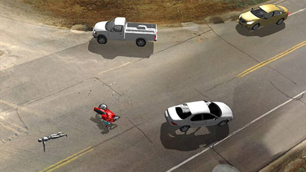
创建二维或三维图表,通过预先绘制的模型、证据图标、尺寸、摆放好的身体,以及照片和报告链接,精确地展示车祸、犯罪或火灾现场。逼真的场景可展示多个光源、高分辨率材质纹理,以及雾、雨、雪天气。
数秒内快速创建车祸动画
使用基于点的精度,使车祸动画与现场捕获到的测量结果精确匹配。包括一些高级效果,如旋转中和抱死的车轮、打开的车门、拖车挂钩连接、爆炸、烟雾和火灾等。
在Zone 3D Expert 中全面分析现场
使用经过独立验证的子弹轨迹和血溅形态分析工具,满怀信心地对现场进行分析。通过 Zone 3D Expert 中的车祸分析工具,使用经过认可的公式执行碰撞分析,根据打滑痕迹、临界速度偏移、动量等计算车速。
Convert Photos and Videos to 3D and Generate Orthographic Images
Use photo and video footage from your drone, phone, or other camera to generate a 3D point cloud with FotoPoints in Zone, allowing first arrivers to quickly document a scene with their mobile devices. Work in 2D with a real-world scale, high-res, top-down image of the scene, enabling a fast and easy way to measure, annotate, and create a 2D diagram for your crash or crime report.
Crash collision, path, and damage prediction
Quickly and easily create "what if" scenarios of various crash types while adding your existing animation to the MassZone system to compare your results with MassZone's prediction animation.
FARO Zone 3D 性能
领先的三维调查软件平台
FARO Zone 3D Pro 是一款针对公共安全专业人员的革命性软件应用程序,也是第一款使调查人员能够在二维和三维环境之间流畅移动,提高事件重建分析质量的软件。对于法医调查员,Zone 3D Pro 提供了使用点云数据来创建法庭交付物的能力。导入人工测量、航空照片、激光扫描或全站仪数据以快速创建二维和三维现场图表。
一个软件搞定所有事情
FARO Zone 3D Expert 包括 FARO Zone 3D Pro 的所有功能 — 如使用来自激光扫描仪和无人机的点云的能力 — 加上将照片转换为点云,确定证人的视角,创建极其逼真的动画,并在虚拟现实环境中分享结果的能力。有了这个最具数据不相关性的软件版本,为出庭做准备从未如此简单。
FARO Zone 3D 功能
FARO Zone 3D Pro 和 FARO Zone 3D Expert 的特点
Rearview Mirrors and Backup Camera
Left, Rearview (Center), and Right-side vehicle mirrors can be placed, positioned, and adjusted to simulate real mirrors in Zone animations and crash predictions. The Zone mirrors will display everything in the scene including point cloud data.
Billboard Annotation Tool
Quickly annotate and identify key elements in any 3D drawing or point cloud with the Billboard tool. Any selected object, text, symbol, or model is instantly elevated on a post always facing the camera, always visible from any viewpoint.
No Point Loss Direct Import of Legacy Point Clouds
Import and convert legacy point cloud data (e57, las, pts) to a lsproj/SCENE point cloud type. Previously, legacy point clouds imported a maximum of 150 million points and did not support gap fill, lighting, and other advanced point cloud settings. As a lsproj file there is no point loss when imported directly from the legacy source file and all Zone point cloud display features will be available.
Generate Report List from Data in Project
One click generates a list of all reports available in your current project.
360° Panoramic Animation
Use “Effective Reality” (no VR gear required) as a tool to turn your Zone animation into a 360° panoramic animation, enabling the user to look in any direction, left to right, up and down and share with anyone with the Windows Movie and TV player.
点云能力
Zone 3D Pro 和 Zone 3D Expert 可以打开多种点云格式,包括激光扫描仪的 .pts 和 .E57 格式,也可以直接从 FARO SCENE 项目或以来自无人机的 .las 文件格式打开。
预先绘制的三维模型
获取大量预先绘制的二维符号和三维模型库,以用于车祸、犯罪和火灾现场。添加一个全面的二维平面图或建筑图表。用预先绘制的符号(如 NFPA 170 和 704 标牌等公认的消防符号)显示门、楼梯、电梯、控制面板、危险材料等,这些符号都包括在内。
精确快速地绘图
多种多样的绘图工具与对象夹取和自动快照功能配套使用,可以轻松地按照确切的尺寸创建精确的二维与三维图表。
灵活的起点
从几乎任何来源获取测量数据、从全站仪导入手动测量数据、从激光扫描仪和无人机导入点云数据。使用 EagleView、Google 或 Bing 的空中地图或无人机数据,创建易于阅读的事件前和威胁评估图表。
具有说服力的三维结果
创建带有阴影、雨、雪、雾、动画汽车前灯、刹车灯、交通灯等元素的逼真俯瞰漫游、车辆和人员动画。
直观的用户界面
其特点是拥有直观的用户界面和持续的反馈、帮助性的操作视频、全面的文档、集成的工作流程指南和免费的教师指导的在线培训。
数据无关紧要的兼容性
支持打开使用 CAD Zone、ARAS 和其他标准 CAD 格式的图表。支持导入人工方法的测量结果、无人机照片、卫星地图、全站仪的数据和激光扫描仪的数据,即使它们由不同的制造商制造。
FARO Zone 3D Expert 独有的功能
Orthographic Images with FotoPoints
Work in 2D with a real-world scale, high-res, top-down image of the scene, enabling a fast and easy way to measure, annotate, and create a 2D diagram for your crash or crime report.
MassZone for Crash collision, path, and damage prediction
Quickly and easily create "what if" scenarios of various crash types while adding your existing animation to the MassZone system to compare your results with MassZone's prediction animation.
一个软件搞定所有事情
FotoPoints 是 Zone 3D Expert 摄影测量引擎,可以让您从任何来源导入照片并将其转换为点云,消除对第三方软件的需求。
充分分析现场
使用经过独立验证的子弹轨迹和血溅形态分析工具,满怀信心地对现场进行分析。车祸分析工具使用经过认可的公式执行碰撞分析,根据打滑痕迹、临界速度偏移、动量等计算车速。
先进的绘图工具
从现场采集的点云中获取所有的测量数据。捕捉特定的数据点来创建精确的图表,用“虚拟测量仪”模式导出所选的点,并使用点云来创建令人惊叹的动画和 VR 场景。
简便的工作流程
合并和校准点云或使用点云模型,将被移走的车辆放回到车祸现场。
FARO Zone 2D、FARO Zone 3D Pro 和 FARO Zone 3D Expert 独有功能
Satellite Image A.I. Vehicle Detection and Clean-Out
Use A.I. functionality to assist in cleaning out vehicles in any Google, Bing, or aerial photo. Remove unwanted vehicles in the Google or Bing satellite image with just a few clicks and create a clean, blank slate of the intersection from an imported satellite image.
Match and Clone
Match or replicate the properties of a selected object to another object in the drawing. Quickly and easily duplicate properties and objects in your scene. Create your own legends using your ideal settings for text, dimensions, line types and save time by matching instead of setting properties.
Favorites Workflow Toolbar System
Create and refine custom workflow toolbars (Symbols, Models, and Tools) to increase productivity and retain proficiency. Select symbols, models, and commands as favorites which you can quickly access, reuse and share. Saved workflows are especially useful after long periods between use.
AXON Upload/Download
Upload and download Zone projects to AXON's secure cloud storage for easy access and sharing of projects.
Import Latest DXF/DWG files into Zone
Import the latest version of ACAD dxf/dwg files into Zone. Zone can work with most data sets. DWG/DXF files are common outputs from other programs and data tools.
FARO Zone 3D 应用
取证分析和事故前规划
为公共和私人调查员创建快速、精确的二维和三维绘图,以帮助执法、火灾原因调查和保险索赔。这些图像有助于车祸情况报告、犯罪现场调查和纵火调查。此外,它们还可通过逼真的三维动画和完全沉浸式的三维环境为法庭演示营造“CSI 效应”,让法官和陪审团成员感觉仿佛重回犯罪现场一样。了解所有取证分析和事故前规划应用 >
相关产品
FARO® Orbis™ Mobile Laser Scanner
FARO Orbis is the all-in-one mobile laser scanner with integrated static scanning capabilities, powered by FARO FLASH technology.
律师和刑事调查人员喜欢使用三维示意图进行法庭展示。
James M. Sparks
Louisville Metro Technology
我们从 FARO 购买产品时,对技术支持非常满意。我们会打电话联系并且立即有人接听。
Chad Mills
肯塔基州法兰克福青少年司法部
我们看到绘制现场的时间缩短了,并且测绘质量也提升了。
Steven Clark
密歇根州波蒂奇市
